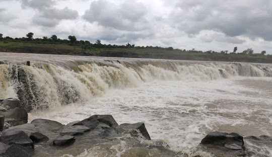
Wardha River
The Wardha River, a cornerstone of central India’s hydrological network, is more than a waterway—it is a cultural emblem, an agricultural lifeline, and a biodiversity hotspot. Spanning 528 kilometers through Maharashtra and Madhya Pradesh, this river merges with the Wainganga to form the Pranhita River, a critical contributor to the Godavari Basin. This article explores the Wardha’s geography, historical legacy, socio-economic impact, environmental challenges, and ongoing conservation efforts, offering a 360-degree perspective on its irreplaceable role in India’s heartland.
Geographical Profile of the Wardha River
Origin and Course
The Wardha River originates at an elevation of 777 meters in the Satpura Range near Multai, Madhya Pradesh—a region also known as the origin of the Tapti River. From its source, the river flows southwest through:
- Madhya Pradesh’s Betul District: A forested region with tribal communities.
- Maharashtra’s Vidarbha Plateau: A semi-arid zone known for cotton farming.
- Confluence with the Wainganga: Near Sironcha (Telangana-Maharashtra border), forming the Pranhita River, which eventually joins the Godavari.
Basin Characteristics
- Total Basin Area: 46,237 km², covering 11 districts across Maharashtra and Madhya Pradesh.
- Key Districts: Wardha, Amravati, Nagpur, Chandrapur, and Yavatmal.
- Soil Types: Black cotton soil (regur) dominates, ideal for cotton and soybean cultivation.
Climate and Hydrology
- Monsoon-Driven Flow: Receives 90% of its annual rainfall (900–1,100 mm) during June–September.
- Seasonal Variation: Summer flow drops to 50 m³/s, while monsoon peaks reach 1,500 m³/s.
- Dams and Reservoirs:
- Upper Wardha Dam (Morna River tributary): Stores 788 million cubic meters for irrigation.
- Nalleshwar Dam: Provides drinking water to Chandrapur.
Tributaries and Watershed Dynamics ( Wardha River )
Major Tributaries
- Penganga River:
- Origin: Ajantha Hills (Maharashtra).
- Length: 676 km; merges with Wardha near Sironcha.
- Significance: Enhances Wardha’s discharge by 30%.
- Bor River:
- Features: Seasonal flow; supports orchards in Wardha district.
- Wunna River:
- Role: Feeds the Upper Wardha Dam, crucial for Nagpur’s water supply.
Watershed Management
- Dendritic Drainage Pattern: Efficient runoff distribution across Vidarbha’s plains.
- Groundwater Recharge: Alluvial aquifers sustain 4,000+ villages.
- Flood Risks: Deforestation in Satpura foothills has increased siltation, reducing water-holding capacity.
Historical Legacy: From Ancient Kingdoms to Gandhi’s Ashram
Ancient Civilizations
- Satavahana Era (1st Century BCE): Archaeological finds near Chandrapur include pottery and coins, indicating trade routes along the river.
- Gond Kingdoms (12th–18th Century): Forts like Chandrapur Fort were strategically built along the river for defense.
Colonial and Modern History
- Cotton Boom (1850s): British East India Company developed Wardha city as a cotton hub.
- Sevagram Ashram (1936): Mahatma Gandhi’s residence near the river became a nerve center for India’s independence movement.
Cultural Heritage
- Markandadeo Temple (Chandrapur): A 12th-century shrine dedicated to Sage Markandeya.
- Festivals:
- Chhath Puja: Devotees fast and offer prayers to the river goddess.
- Makar Sankranti: Kite-flying festivals on its banks.
Economic Pillar: Agriculture, Industry, and Energy
Agriculture
- Key Crops: Cotton (70% of Maharashtra’s production), soybeans, pulses, and oranges.
- Irrigation Infrastructure:
- Upper Wardha Project: Irrigates 250,000 hectares.
- Pench River Diversion: Supplies water to drought-prone areas.
Industrial Growth
- Coal Mining:
- Western Coalfields Limited (Chandrapur): Produces 40 million tonnes annually.
- Environmental Cost: Acid mine drainage pollutes river water.
- Thermal Power:
- Chandrapur Super Thermal Power Station: 2,940 MW capacity; consumes 28,000 m³ of river water daily.
Hydropower and Drinking Water
- Upper Wardha River Hydroelectric Project: Generates 15 MW, powering 30 villages.
- Nagpur’s Water Supply: 40% sourced from Wardha’s tributaries.
Environmental Challenges: Pollution and Habitat Loss
Pollution Hotspots
- Industrial Effluents:
- Coal Washeries: Release toxic heavy metals (lead, mercury).
- Textile Units (Hinganghat): Dump untreated dyes into the river.
- Agricultural Runoff:
- Pesticide Contamination: 65% of water samples exceed WHO nitrate limits.
- Eutrophication: Algal blooms reduce oxygen levels, killing fish.
- Sand Mining:
- Illegal Dredging: 200+ unauthorized sites disrupt riverbeds.
- Impact: Endangers gharials and freshwater turtles.
Deforestation and Erosion
- Satpura Hill Slopes: 30% forest cover lost since 2000, increasing siltation.
- Flood Vulnerability: 2019 floods displaced 50,000 in Chandrapur.
Biodiversity Decline
- Threatened Species:
- Mahseer Fish: Population down 60% due to dams.
- Indian Skimmer: Rare birds displaced by habitat fragmentation.
- Wetland Degradation: 12 wetlands dried up in Amravati district (2015–2022).
Tourism and Ecological Retreats
Natural Attractions
- Pench Tiger Reserve:
- Location: Borders Madhya Pradesh and Maharashtra.
- Wildlife: Tigers, leopards, and 285 bird species.
- Tadoba-Andhari Tiger Reserve:
- Highlights: Jungle safaris along the Wardha’s tributaries.
Cultural and Historical Tourism
- Sevagram Ashram: Displays Gandhi’s letters and spinning wheel.
- Chandrapur Fort: Offers panoramic views of the river valley.
Adventure Tourism
- Boating at Upper Wardha Dam: A popular weekend activity.
- Birdwatching at Lonar Lake (meteorite crater near the basin).
Conservation Initiatives: Restoring the River’s Health
Government-Led Programs
- Namami Godavari Mission:
- Budget: ₹20,000 crore (2021–2026).
- Goals: Sewage treatment plants in 15 Wardha-basin cities.
- Maharashtra River Rejuvenation Project:
- Afforestation: 100,000 saplings planted in 2022.
Community-Driven Efforts
- Eco-Pro (Nagpur NGO): Organizes annual “Clean Wardha” drives.
- Farmers’ Cooperatives: Promote organic farming to reduce chemical use.
Legal Interventions
- National Green Tribunal (NGT) Orders:
- Banned sand mining within 500 meters of bridges (2020).
- Fined coal plants ₹50 crore for effluent violations (2021).
The Road Ahead: Sustainable Development Strategies
Eco-Friendly Agriculture
- Drip Irrigation: State subsidies for 5,000 farmers to reduce water use.
- Biofertilizers: Training programs for soybean growers.
Renewable Energy Shift
- Solar Parks: Proposed 500 MW project in Wardha district to offset coal dependency.
Ecotourism Policies
- Carrying Capacity Limits: Restrict tourist numbers in Tadoba Reserve.
- Community Homestays: Promote rural tourism in riverine villages.
Climate Resilience
- Flplain Zoning: Prohibit construction in high-risk flood areas.
- Early Warning Systems: SMS alerts for 500 riverside villages.
Conclusion
The Wardha River embodies the delicate balance between human progress and ecological preservation. While industries and agriculture drive the region’s economy, unchecked exploitation threatens its survival. Collaborative efforts—from stricter pollution controls to community education—are vital to safeguard this lifeline. By embracing sustainable practices, we can ensure the Wardha continues to sustain biodiversity, culture, and livelihoods for centuries.


Leave a Comment